1/14


São Paulo Metro - Official
1K+ดาวน์โหลด
37.5MBขนาด
12.1.10(18-12-2024)เวอร์ชั่นล่าสุด
รายละเอียดรีวิวเวอร์ชั่นข้อมูล
1/14
คำอธิบายของSão Paulo Metro - Official
"Sãoเปาโลเมโทร - อย่างเป็นทางการ" การประยุกต์ใช้เป็นวิธีที่เร็วที่สุดเพื่อ map และวางแผนเส้นทางของคุณเพื่อการนัดหมายและการสู้รบรอบSãoเปาโลใช้ระบบรถไฟฟ้า
ใบสมัครเป็นความคิดริเริ่มของ บริษัท Sãoเปาโลเมโทรโพลิแทนรถไฟ - METRO
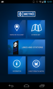
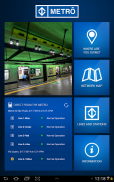
ฟังก์ชั่นและทรัพยากร:
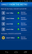
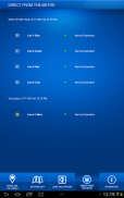
- ตรงจากสถานีรถไฟใต้ดิน
การติดตามเวลาจริงของสถานะการดำเนินงานของแต่ละสาย
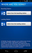
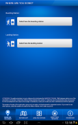
- คุณต้องการไปที่ไหน
การจำลองขั้นตอนโดยขั้นตอนของเส้นทางที่เร็วที่สุดระหว่างสองสถานีรวมทั้งเวลาและค่าใช้จ่ายโดยประมาณแผนที่บ้านใกล้เรือนเคียง ฯลฯ
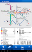
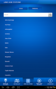
- แผนที่เครือข่าย
แผนที่ภาพของทั้งรถไฟใต้ดิน
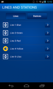
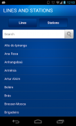
สายและสถานี -
ดูรถไฟใต้ดินและสถานี ชั่วโมงให้คำปรึกษาในการดำเนินงานสถานที่ ฯลฯ
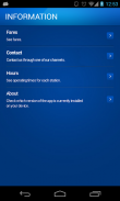
- ข้อมูล
ดูค่าโดยสารหมายเลขโทรศัพท์ให้ความช่วยเหลือและบริการชั่วโมงสำหรับแต่ละสถานี
São Paulo Metro - Official--เวอร์ชั่น12.1.10
(18-12-2024)ข่าวใหม่Update to Direto do Metrô.
รับประกันแอปดี!แอปนี้ผ่านการทดสอบความปลอดภัยด้านไวรัส มัลแวร์ และสิ่งโจมตีอื่นๆ
และไม่มีสิ่งคุกคามใดๆ
São Paulo Metro - Official - ข้อมูล APK
เวอร์ชั่น APK: 12.1.10แพ็คเกจ: br.com.metrosp.appmetroชื่อ: São Paulo Metro - Officialขนาด: 37.5 MBดาวน์โหลด: 391เวอร์ชั่น : 12.1.10วันที่ปล่อย: 2024-12-18 02:55:42หน้าจอขั้นต่ำ: SMALLCPU ที่รองรับ: x86, x86-64, armeabi-v7a, arm64-v8a
ID ของแพคเกจ: br.com.metrosp.appmetroลายเซ็น SHA1: A7:68:BD:17:EB:0A:21:34:93:D9:D7:01:60:23:07:A5:A2:70:6C:1Eนักพัฒนา (CN): Companhia do Metropolitano de São Paulo - Metrôองค์กร (O): ท้องถิ่น (L): ประเทศ (C): รัฐ/เมือง (ST):
เวอร์ชั่นล่าสุดของSão Paulo Metro - Official
12.1.10
18/12/2024391 ดาวน์โหลด37.5 MB ขนาด
เวอร์ชั่นอื่น
12.1.9
10/6/2024391 ดาวน์โหลด37.5 MB ขนาด
12.1.4
29/2/2024391 ดาวน์โหลด37.5 MB ขนาด
12.1.2
2/2/2024391 ดาวน์โหลด37.5 MB ขนาด
12.1.1
5/1/2024391 ดาวน์โหลด39 MB ขนาด
12.0.0
4/11/2023391 ดาวน์โหลด37.5 MB ขนาด
2.7.6
15/12/2022391 ดาวน์โหลด40 MB ขนาด
2.7.5
20/10/2022391 ดาวน์โหลด40 MB ขนาด
2.7.1
29/1/2021391 ดาวน์โหลด38.5 MB ขนาด
2.7.0
19/12/2020391 ดาวน์โหลด38.5 MB ขนาด


Z Warrior Legend 3.87
3.87
3.87


แอปในประเภทเดียวกัน

คุณอาจจะชอบ...

English


